


tour de Fessole

CABERMAT
User
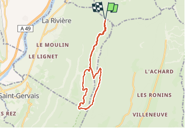

Length
14.6 km

Max alt
1616 m

Uphill gradient
860 m
Km-Effort
26 km

Min alt
1071 m

Downhill gradient
871 m
Boucle
Yes
Creation date :
2023-05-04 07:32:41.295
Updated on :
2023-05-04 19:40:37.31
5h53
Difficulty : Difficult

FREE GPS app for hiking
 SityTrail
IGN / Geographical institutes
SityTrail Plus
The world is yours!
About
Trail Walking of 14.6 km to be discovered at Auvergne-Rhône-Alpes, Isère, La Rivière. This trail is proposed by CABERMAT.
Positioning
Country:
France
Region :
Auvergne-Rhône-Alpes
Department/Province :
Isère
Municipality :
La Rivière
Location:
Unknown
Start:(Dec)
Start:(UTM)
699395 ; 5012587 (31T) N.
Comments